Sunday, September 26, 2010

October 2010 Forecast/Discussion

Telleconnection Discussion/Forecast

NAO:The NAO has been averaging Slightly Negative [~-0.4] since June, what this means is that while we have had major heat over the Summer, the NAO has actually been Negative, which is likely due to a lower/negative correlation with Temperatures in Summer. Where are we going?
http://www.cpc.noaa.gov/products/precip/CWlink/daily_ao_index/teleconnections.shtml
NAO looks to hang around Neutral over the next several weeks, with any possible direction after that being a decent possibility;Hence I am going for a overall NEUTRAL NAO for October 2010.

PNA:The PNA has been averaging Slightly Positive [~0.4] since June, which is unique in a way that since we got we are in a La Nina/-PDO phase, the PNA has a high correlation to the PDO. The PNA over the last couple of days has went negative for the first time in almost 2 months. Where are we going?

There are mixed signals on where the PNA may go, even though the GFS wants to bring it positive, -ENSO/-PDO combo goes against a +PNA;Hence I am going for a overall NEUTRAL PNA for October 2010.

ENSO:At the moment, the ENSO state is ~at Moderate Nina levels, though readings are showing Strong Nina values, and it is Central-Based/Basin-Wide at the current time. I would say October '10 analogs are;54, 64, 70, 73, 88, 98, 07

This shows a Slight Warm tendency especially in the Midwest/Northeast, and a Slightly Wet tendency over the OV. Although the years by themselves could be a lot different.

Temperature Discussion/Forecast

SE Ridge tendency comes in to play regardless of near neutral NAO/PNA, also a possible SW ridge. North is overall cold with Cold Fronts briging in short periods of very cold air, though they wont have the effect of the SE Ridge, which is the reason they will average Below Normal. I think that the Below normal anomalies in the North may suprise some, I think there is a day or two where these areas dont get above 45, maybe even 40, these areas will also have occasional Frost/Freezes because of this.

Precipitation Discussion/Forecast


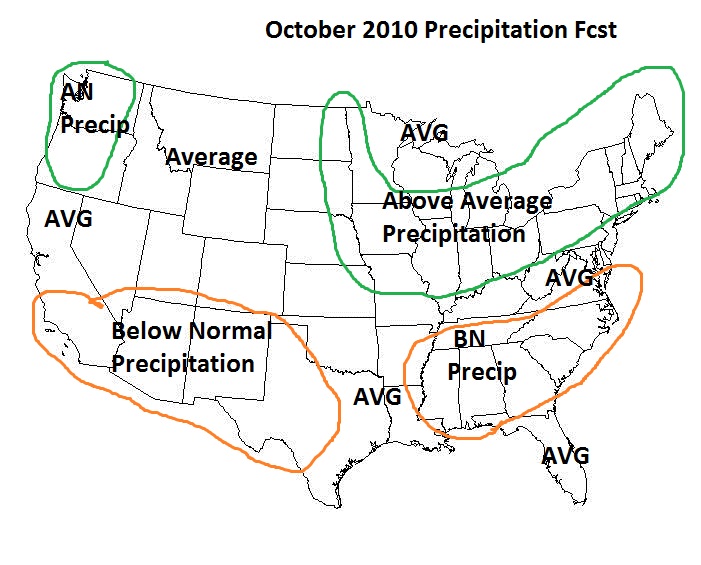
Below normal precipitation will take place across the South due to a Weak/Nonexistent STJ and a SE Ridge, though isolated locations could be Average or Above Average in the Aformentined areas due to possible Thunderstorm action or possible Tropical action. The North will have Above average precipitation due to a Dominent/Strong PJ, this will spin up lots of systems, some will be cross country travelers, Canada systems, and possibly a GLC or an AR for the Northeast.

And for Shits and giggles, Wintry potential
Forecast Confidence:7/10

Comments would be appreciated :)

Wednesday, August 25, 2010

September 2010 Forecast/Discussion

Discussion:Weak-Moderate La Nina will bring a classic Nina pattern this month as I see no major pattern differences, also because of the very warm east over the summer. The Southeast, Mid Atlantic, and Southern New England will have Above average temps and Below average precip due to a SE Ridge, the SW also looks this way. The Rockies, Southern and Central Plains, Ohio Valley, Southern Great Lakes area, Western Northeast, Central New England, and Southern New England look about average in terms of temps and precip, although it could go either slightly above average/below average in Temps/Precip though, but this area should have closer to ''Normal'' departures. The Northwest, Upper Plains, Midwest, and Upper Great Lakes looks to have Below average temps and Above average precip due to a strong PV and a moisture flow through the Northern US/Southern Canada;I think there are potentials for Frost/Freezes and maybe even some flurries/light snow events in the later part of the month, especially in the most northern areas and high altitude areas. For Hurricane activity, it will be a little more likely than last month, since were getting right into the middle of Hurricane Season.

Factors for this month
Near neutral NAO/AO
+EPO
-PNA
Rising/+QBO

What could go wrong?

1. SE ridge doesnt develop and we get a further south storm track and allows the PV to go further south, allowing for colder temperatures and more precip in the SE/MA.
2. The Pacific gets so ugly that over 1/2 of the country torches, aka a 1998-1999/1999-2000, it is possible with a Decent La Nina/+QBO/+EPO pattern, I doubt it, but we'll see.

Confidence:7/10

Comments and Suggestions are Appreciated:)

Tuesday, August 17, 2010

August 18th-19th 2010 Rainfall forecast

In the last few days, Tropical Depression 5 [or the remenents of it] has been swirling around in the northern Gulf of Mexico, which is loading up ample moisture into the South, ATM the Low has come ashore in Louisiana. Now what is going to make this interesting is that moisture is going to run up into a Stationary Cold front, here it is right now.


As you can see there is a ton of moisture in the Southeast right now, and there is no big HP to the north which should allow this moisture and even the front to edge back north.

So here is my overall rainfall forecast for tomorrow.

**More or less QPF locally**

I am going on a blend of the NWS/HPC/NAM on this IMO.

Wednesday, August 4, 2010

Thursday, August 5th, 2010:Weather/Temperature Forecast

My opinion of what this winter could bring.

Yellow=Warmer than Normal Temperatures
Green=Mainly Rain Storms
Light Green=Mainly Rain Storms, some Snow/Ice storms
Pink=All types of storms possible
Dark Gray=Snow Jackpot Zone
Light Gray=Light Snow
Blue=Colder than Normal Temperatures
Brown=Dry

Tuesday, August 3, 2010

Wednesday, August 4th, 2010:Temperature/Weather Forecast


Ways I will rate storms/other

Low Pressure Strengh [US/South Canada]
1000-1010mb=Weak Low Pressure
990-1000mb=Moderate Low Pressure
975-990mb=Strong Low Pressure
960-975mb=Very Strong Low Pressure
<960mb=Historically/Near Historically Strong Low Pressure

High Pressure Strengh [Eastern US/SE Canada/Western Atlantic]
1015-1020mb=Weak High Pressure
1020-1025mb=Moderate High Pressure
1025-1035mb=Strong High Pressure
>1035mb=Very Strong High Pressure

[Central/Western US/N/EPacific/Southern Canada]
1015-1020mb=Nuisance High Pressure
1020-1025mb=Weak High Pressure
1025-1035mb=Moderate High Pressure
1035-1045mb=Strong High Pressure
>1045mb=Very Strong High Pressure

Storm Track [US/South Canada]
Coastal Storm/Miller A=LP that is just off the coast of the EUS and has an effect to the Major Cities, must not exit right.
Supressed Storm=LP that doesn't make it to 40N or doesnt effect anyone in the VA to ME areas.
Inland Runner=LP that travels between the Atlantic Coastline and the Appalachians.
Appalachian Runner=LP that travels somewhere between 1-81 and WV/West PA.
Great Lakes Cutter=LP that travels over the Great Lakes.
Miller B=LP that travels through the MW/GL and then hits the Atlantic and strenghens.
Alberta Clipper=LP from Canada.

Temperature Departure Daily [Oct to Mar]
-2 to +2=Normal/Average
+2 to +5=Slightly Above Average
+5 to +15=Above Average
+15 to +25=Way Above Average
>+25=Record/Near Record High Temperatures
-2 to -5=Slightly Below Average
-5 to -15=Below Average
-15 to -25=Way Below Average
<-25=Record/Near Record Low Temperatures

[Apr to Sep]
-1 to +1=Normal/Average
+1 to +4=Slightly Above Average
+4 to +10=Above Average
+10 to +15=Way Above Average
>+15=Record/Near Record High Temperatures
-1 to -4=Slightly Below Average
-4 to -10=Below Average
-10 to -15=Way Below Average
<-15=Record/Near Record Low Temperatures

Monthly/Seasonal
-0.5 to +0.5=Average/Near Average
+0.5 to +2=Slightly Above Average
+2 to +5=Above Average
>+5=Way Above Average/Record High
-0.5 to -2=Slightly Below Average
-2 to -5=Below Average
<-5=Way Below Average/Record Low

Welcome to wxunleashed

Hello people, I am starting a new website consisting of my weather forecasts and details, mainly for the East Coast, but also the rest of the United States.

Here are the type of posts I will have.

Current Weather Maps [0hrs to 12hrs out and for 0z and 12z] [East Coast only]
Weather Forecasts [0hrs to 18hrs out] [East Coast only]
Storm Forecasts/Observations [East Coast only]
Severe Weather Forecasts/Observations [East Coast only]
Medium/Long Range Forecasts [8 to 20 days out] [All of US]
Monthly Forecasts
Seasonal Forecasts
and more cool stuff